Gwanaksan
관악산Sadang Ridge → SNU Eng. Valley
This is my favorite hiking route on Gwanaksan Mountain. It offers the best accessibility from the subway station to the trailhead. While the beginning and the final stretches are quite steep and challenging, the middle section follows a ridge line, making for a pleasant hike with spectacular views. Descending from Yeonjudae to the SNU College of Engineering is the fastest way down. After finishing the trail, you shouldn't take the bus right in front of you; instead, walk about 200 meters to the 'Engineering Building 2' stop. From there, take the 2-1 green bus, and you’ll reach Nakseongdae Station in about 20 minutes. A big plus is that since it’s the terminus, you’ll be able to get a seat and ride in comfort.
Gwanak Stream Trail → Sadang Ridge
This hiking route starts from Gwanaksan Station (Seoul National University) on the Sillim Line. Inside the station, you'll find the Seoul Hiking Tourism Center, where you can conveniently rent hiking gear (please note that it is closed on Wednesdays). There are plenty of restaurants and convenience stores right outside the exit, and the trailhead begins immediately as you step out. The initial part of the course follows the outer roads of the SNU campus and continues as a gentle climb along the valley. While it’s an easy and accessible path for beginners, the scenery can be somewhat monotonous, making it feel a bit tedious at times. It is, however, the most well-known and popular route. In contrast, the ridge course heading down from Yeonjudae toward Sadang Station offers stunning, open views that will keep you engaged the entire way. However, since it's a ridge trail with several ups and downs, it can be quite taxing on your legs if your energy is already spent from the ascent.
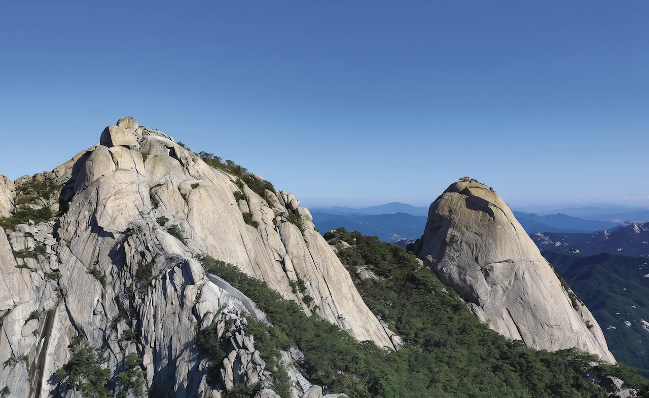
Jaunam Ridge → Mushroom Rock Ridge
This loop trail starts at the SNU College of Engineering, ascends to Yeonjudae Peak via the Jaun-am course, and returns through the Mushroom Rock Ridge. While the entire ridge course offers spectacular views, it involves many technical rock-scrambling sections, making hiking boots mandatory. The descent via Mushroom Rock Ridge is secluded and easy to lose track of, so following a GPS path is highly recommended.
Inwangsan
인왕산Inwangsan Course (Seoul City Wall Trail)
This is the Inwangsan Mountain section of the Hanyangdoseong (Seoul City Wall) Trail. Since the path starts through a residential alleyway, it’s a good idea to check the route beforehand. The trail isn't too steep, so sneakers are perfectly fine. Once you reach the summit, you'll be rewarded with a stunning night view of Seoul.
Ansan
안산Dongnimmun Station (Muakjae) → Hongje Falls
Ansan is a welcoming, easy-to-climb mountain facing Inwangsan across the Muakjae Sky Bridge. This route leads from Dongnimmun Station toward the bridge and straight to the Beacon Mound summit, but I personally recommend the wooden deck loop trail for a relaxing family stroll. The path ends with a descent to the popular Hongje Falls, followed by a short bus ride to Hongje Station.
Bukhansan
북한산Bukhansanseong Entrance → Ui Valley
The route starting from Bukhansanseong Entrance is one of the most frequently used paths, but there is some inconvenience of having to take a bus. Although the trail along the valley can be a bit tedious, I think many people use it because of the clean valley water and the peaks revealing themselves here and there. The path itself has no dangerous spots except for the final climb to Baegundae. For the descent, I came down toward Ui-dong Valley, and I reached the beginning of the trail quickly. However, since I had to move almost the same distance again to the subway station, it felt longer in terms of perceived distance.